Langthorpe Loop

The LangthorpeLoop
This is a circular walk of history and imagination, taking in the site of an ancient battle, a prisoners’ cell, a key point on the Great North Road and a windmill whose ownership rested on a dead man’s fate.
The walk starts close to two river crossings – one long gone and one that is still in use today. There was a ford, downstream at Milby Lock, as long ago as Roman times and the stone bridge which now crosses the River Ure was built in 1562 and widened in 1784.
Walk Information
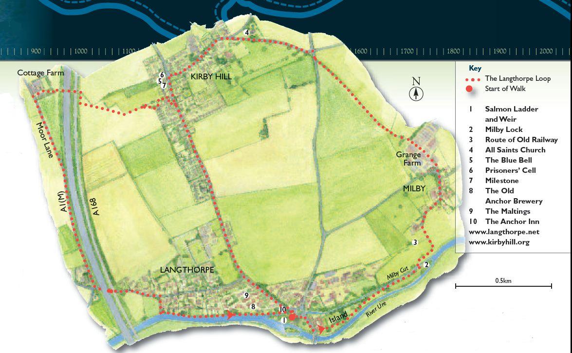
The full walk is three miles (5km) long and should take around two hours at a steady pace. Start at the walk interpretation panel in the Langthorpe picnic area car park, off the roundabout at the end of the bridge over the Ure. Follow the route shown by the blue waymarkers.
OS Map Explorer 299 covers the area.
Buses serve Boroughbridge (www.northyorkstravel.info)
The Route
In the 11th century, the bridge was a wooden construction. And in 1322, the bridge and the ford were key strategic locations in the Battle of Boroughbridge.
On March 16, Sir Andrew Harcla, Governor of Carlisle and supporter of King Edward II, fought the rebellious Thomas, Earl of Lancaster here. Harcla’s pikemen stood at the northern end of the bridge while more pikemen and archers waited on the far bank at the ford. The Earl of Hereford led a charge on foot to the bridge while the Earl of Lancaster led a mounted assault to take the ford, but Harcla’s men stood firm, rebuffing both assaults. The next day, Harcla marched into Boroughbridge and arrested Lancaster, who had sought sanctuary in the now-demolished church in St James Square,where the fountain stands.
Head for the bridge, cross the road and take the footpath alongside the river. You leave the island by walking over Milby Lock, one of six authorised by Parliament in 1776 to make the river navigable as far as Ripon.The work, including the Ripon Canal itself, was designed by John Smeaton, who was also responsible for the Eddystone lighthouse. The engineer was William Jessop.
Take the lane to the left, across the route of the old railway, which first reached here in 1848. Locomotives sounded the death knell for the canals, but the line in turn was closed in the 1960s.
Pass through Milby and onto a green lane and you’ll reach the attractive, historic church of All Saints at Kirby Hill. Part of the churchyard is managed for the benefit of wildlife such as plants, insects and birds.
The Blue Bell, an old coaching inn, still boasts a cell in its grounds where prisoners bound for York could safely be chained up at night. The inn stands on the Great North Road which once carried stagecoaches bound for Edinburgh and Newcastle – the route was moved west to become the A1 in
1962. Look for an old milestone to the left of the inn, showing the miles to London where it marks a spot exactly half way between the capitals of Scotland and England.
Head downhill, towards the footpath on the right which will take you to the footbridge. (You can shorten the route by simply continuing down the road back to the start.)
Pause at the footbridge which crosses the A1(M) and you’ll see the Skelton windmill, built in 1822. It’s often referred to as the Kirby Hill windmill, but when the people of that hamlet refused to bury a vagrant found dead there, the people of Skelton stepped in and laid the man to rest. As a result, Skelton claimed the windmill and land for their parish. Turn down Moor Lane (be careful, you may not hear approaching traffic).
Go under the A1, turn right down to the Ure and, providing it’s not in flood, through some delightful Langthorpe gardens on its banks. You’ll see the old Anchor Brewery building (the Anchor Inn here was its flagship inn) and the Maltings, both now converted to housing.