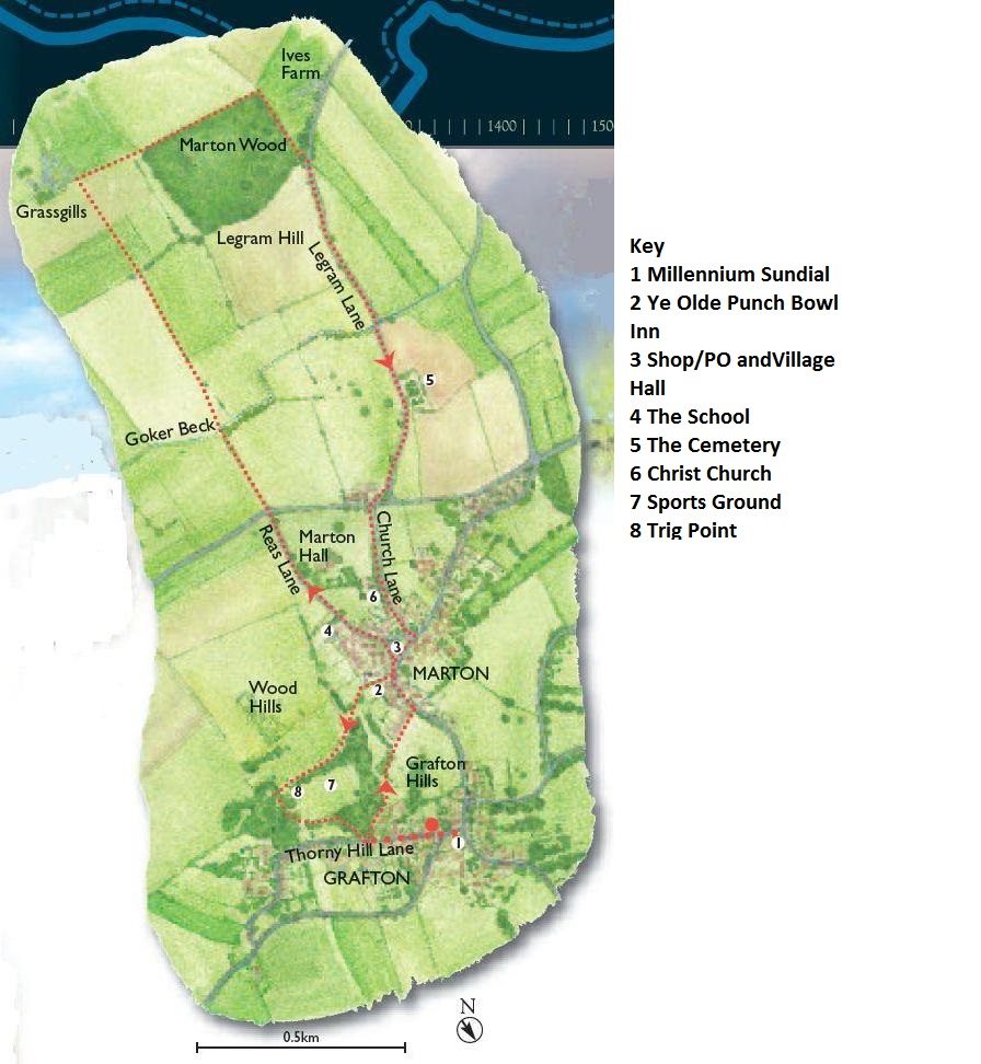
Marton cum Grafton Eight

The Marton-cum-Grafton Eight (Please note that this walk is blocked beyond Goker beck)
This figure-of-eight walk around the twin settlements of Marton-cum-Grafton shows you some glorious panoramic hilltop views, tells you a tale of two churches and stands you next to a map-making high point.
References to this area go back at least as far as the Domesday Book where lands at Marton were listed as belonging to the Priory of Nun Monkton and an entry can be seen for the Archbishop of York’s estate at Grafton. But today you’ll be exploring two small but thriving villages, using some of the extremely ancient pattern of roads and paths which has been carefully maintained here, and taking an easy stroll out into the countryside to the south.
Walk Information
The full walk is three miles (5km) and should take around two hours at a steady pace. The Country Loop is just under two miles (3km) and should take an hour. The Village Loop is just over one mile (2km) and should also take around an hour.
Park thoughtfully near the green in Gratfon. Start at the walk interpretation panel on the roadside verge.
Following the route shown by the purple waymarkers. A hilly walk with stiles and, on the Village Loop, a number of steps. Ye Olde Punch Bowl Inn past the church and along Legram Lane is suitable for wheelchairs and scooters.
OS Map Explorer 299 covers the area.
Buses serve Marton-cum-Grafton (www.northyorkstravel.info)
www.marton-cum-grafton.org www.martoncumgraftonhistory.com
The Route
Before or after your walk you may wish to stand on the Millennium Sundial on the village green. Where your shadow falls tells you the time.
Facing the interpretation panel turn left to go uphill onThorny Hill Lane. When you near the brow of the hill, look for a fingerpost on your right where the woodland starts. The footpath brings you to Grafton Hills which are, along with nearby Wood Hills, the highest point for 20 miles around. The flock of handsome Soay sheep may be about. Pause for a look back across the lovelyVale of York and the lower UreValley.
As the route continues, you’ll enter Marton, passing the 16th centuryYe Olde Punch Bowl Inn. As you walk down Reas Lane you’ll see the school, built in 1861, before you follow a track down to cross Goker Beck which flows down into the River Ure. Going uphill from the beck you’ll climb through a type of stile known as a ‘squeeze’ stile.
Look out across the fields for birds such as skylark, yellowhammer, pheasant, partridge, redwing and fieldfare, depending on the time of year. If you’re really lucky you might spot a corn bunting.
The route continues past farm buildings and then behind Marton Wood before bringing you onto Legram Lane. Look for the cemetery on your left which was once the site of Marton’s church. It is now also a nature reserve.
The church was demolished in 1873 on the orders of the Reverend John Lunn, and you’ll see the replacement he built further on as you cross over into Church Lane. Christ Church was built in 1875 using much of the carved stone from the previous building. It houses the second oldest church bell in the country on the side of the church. Inside, the font dates from 1320, and is well worth seeing.
Continue into the village past the shop and village hall and head down the right hand side of the pub car park. You’ll find yourself reaching a high point on a path by the Sports Ground which gives you spectacular views across to the White Horse of Kilburn, as well as York Minster.
With ups and downs, the result of this ground having been used to quarry gravel, you’ll pass a white Trig Point. Standing at 75 metres above sea level, this is one of thousands of high-point markers used by the map makers of the Ordnance Survey. This was once the site of an Iron Age Hill Fort and you, like those ancient ancestors, can enjoy excellent views.
Finally, take the pathway down toThorny Hill Lane.The shops, pub and businesses which used to be here are long gone, but their names can still be seen on some of the houses as you turn left and downhill to the start.